
COUNTER PROPOSAL
FOGC Counter Proposal (2024)
Developed by Friends of Gadsden Creek (FOGC), this proposal is a visualization of the urgent demands crafted by Gadsden Green residents from 2022-2024. The different sections of the document outline principles of how these demands could be met in new designs for Gadsden Green and Gadsden Creek. This document will be used for advocacy, as a resident-led vision and north star for what is possible in Gadsden Green. In the case that Gadsden Green is redeveloped, this proposal will be used to push for development that matches the desires of the community. If there is any new development in the community, FOGC will fight for it to be high quality and community-sensitive, for the benefit of current Gadsden Green residents.
This document is a companion to “Gadsden Creek Revitalization Project” by Robinson Design Engineers, which outlines concepts to improve water quality and flooding in the area.
We encourage all advocates and “Friends” to share and circulate. To download the Counter Proposal as a PDF, click HERE.
reports
Gadsden Green Neighborhood Conditions & Community Change (2020)
FOGC x Pratt Institute Graduate Center for Planning and the Environment
Horizon TIF: MUSC Discovery District (2021)
FOGC x Pratt Institute Graduate Center for Planning and the Environment
documents
1822_PLAT.pdf
Demonstrates that Thomas Gadsden, slave auctioneer, is the landowner of Gadsden Creek.
1850s_PLAT.pdf
Demonstrates Thomas Gadsden’s valuable holdings. Gadsden Creek in upper left.
1852_PLAT.pdf
Shows Thomas Gadsden’s holdings, subdivisions, grid urbanism. Relationship between Gadsden Green community butted up against the creek.
1857USGS SURVEY.pdf
Shows Gadsden Creek.
1867_BAPTISM.pdf
April 1, 1867 - “Negro Baptism” in Gadsden Creek.
1872—07-25_NEWS.pdf
”Free Baths for the Boys” - document detailing how Chief of Police responds to complaints of bathing boys - by designating 3 bathing areas, one of which is Gadsden Creek. White regulation of Black recreation.
1877_PLAT.pdf
Shows Gadsden Creek area as one of low density use.
1902_Sanborn Fire Map.jpeg
Color map clearly showing Gadsden Creek pre land-fill.
1914_PLAT.pdf
Plat that goes alongside 1914 court case of Gadsden vs. West Shore Investment Company - determining that City of Charleston is landowner. Demonstrates how mighty Gadsden Creek was.
1914-01_COURTCASE.pdf
1914 legal case exploring ownership of Gadsden Creek - conclusion: The City of Charleston owns Gadsden Creek.
1914—10-05_CASE.pdf
More on 1914 case establishing City of Charleston ownership of Gadsden Creek.
1927_PLAT.pdf
Confederate Naval Cemetery near Gadsden Creek demonstrates that the area is on the outskirts of the city, ie: where cemeteries are located.
1929_PLAT.pdf
Demonstrates Gadsden Creek-proximate Black use and Civil use. Shows “Stadium” (later to become Johnson Hagood Stadium, relevant because the City attempted to bar Black soldiers from using this facility) adjacent to “Marsh” and “Stable” (likely a Colored Farmers Fair facility.)
1934_AERIAL.pdf
Aerial photograph showing the vernacular/historic single-family homes of the Gadsden Green community abutting Gadsden Creek. An aerial photograph superimposing names of current-day streets.
1938-11_NEWS.pdf
Newspaper clipping chronicling YMCA fundraising event to go towards “tornado [1938] sufferers of the Gadsden Green area”
1940-03-25_CITIZENS.pdf
1940 letter by John Harris + 39 Gadsden Green residents to Mayor Lockwood, protesting the seizure of property to create Gadsden Green Homes public housing complex.
1940-03-29_MAYOR.pdf
Reply from Mayor Lockwood, effectively saying “Too late, too bad.”
1940 United States Municipal News article exemplifying US frenzy for Urban Renewal: aka slum clearance + homogenous public housing. Charleston’s Robert Mills Manor used as a shiny case-study.
+
1941 letter from President of Harmon Foundation, who refuses to allow Harmon Field to be used as a military training site in preparation for WWII. The City of Charleston offered Harmon Field to the Secretary of War as a non-valuable site, as it was primarily used by the African-American Gadsden Green residents.
1940-10-16_PLATS.pdf
Plan of Gadsden Green lots prior to seizure, demolition and installation of public housing.
1941 - WreckingGadsdenGreen-EveningPost30Apr1941.png
City sells off lumber and material from Gadsden Green houses prior to demolition and erection of public housing. Obvious contradiction in that the City pushes a narrative of “these homes are wrecked, we must built this new complex”, while simultaneously profiting off of the homes seized from Gadsden Green residents, which are in “good repair.”
1941-05-31_CITY.pdf
After Harmon Foundation rejects Charleston’s request to offer up Harmon Field to Secretary of War for military training, Charleston instead offers up Stoney Field (aka Hagood Stadium) - but explicitly limits use to White soldiers.
1949-06-13_CITY.pdf
Fishy letter from City’s Attorney (“Clerk of Council”) expressing concern that the Top 4 Wards of the city (which are Black) make up 60% of the population. Requires more analysis - but seems to be a desire to redistrict because Black population majority threatens White voting majority.
1950_PHOTO.pdf
Photo of swimming pool at Harmon Field populated by many Black Gadsden Green residents. Beginnings of landfill apparent in background of photo.
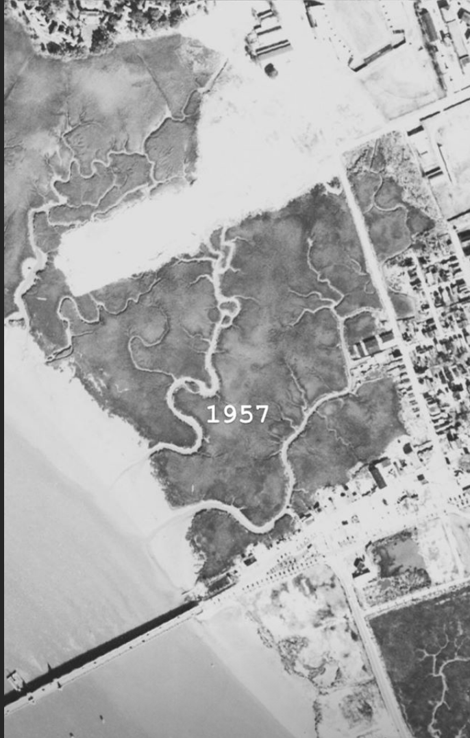
1951-Sanborn Fire Map.jpeg
Color map clearly showing Gadsden Creek after the construction of Gadsden Green public housing.
1953_BILLBOARD.pdf
Clipping from Billboard Magazine advertising “Charleston County Colored Farmers’ Fair” in the "Heart of Town - Harmon Field.” Evidence of the rich cultural activity in the Gadsden Green community, which would later be shut down and seen as a “sore thumb” by Mayor Morrison.
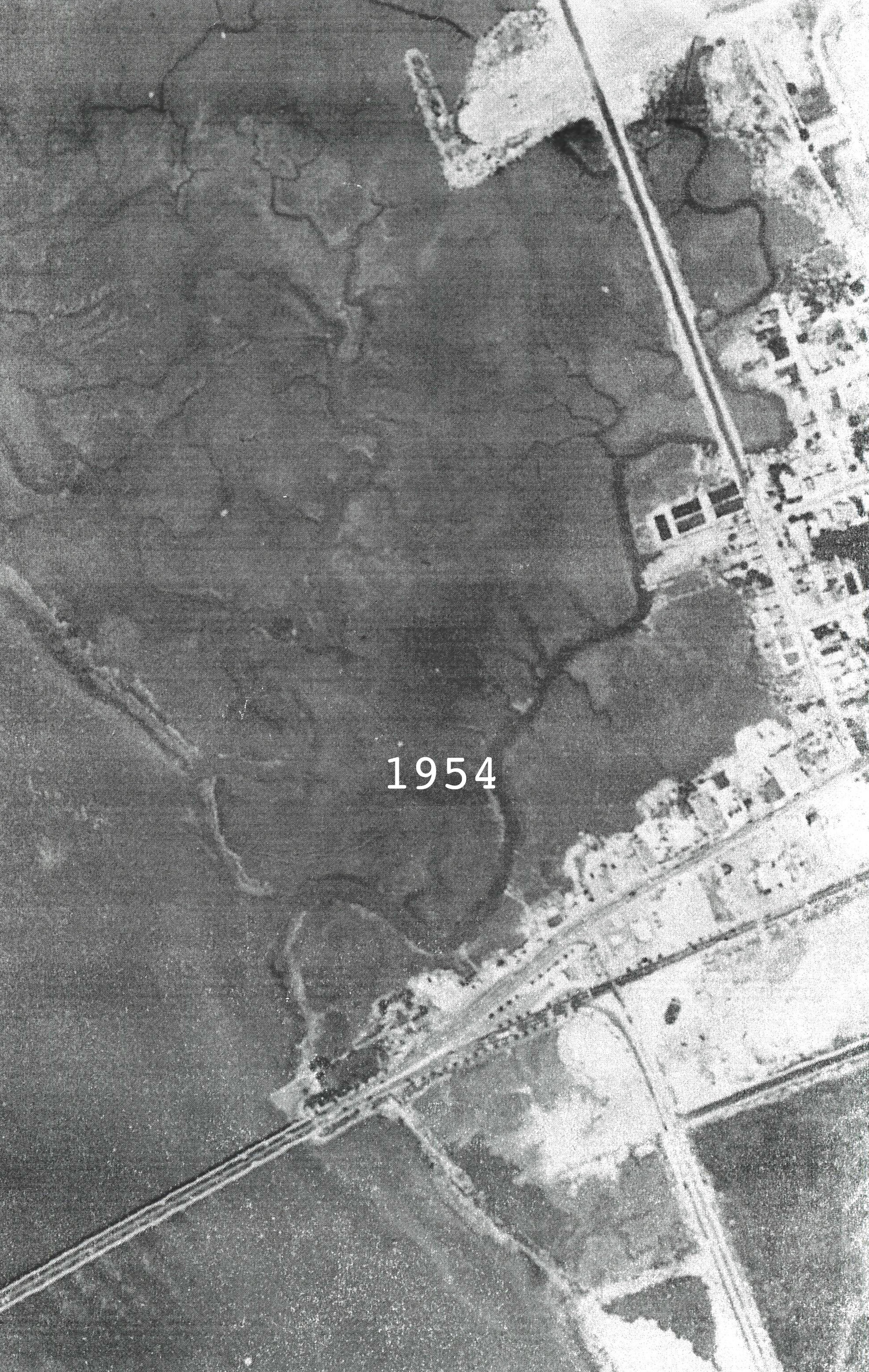
1954_AERIAL.pdf
Aerial photo depicting Gadsden Creek at the beginning of the landfill process.
1955_PLAT.pdf
Plat depicting Harmon Field swimming pool, Gadsden Creek, and the tract of land where landfill is being dumped.
1955-Sanborn Fire Map.jpeg
Color map showing Gadsden Creek being covered and pushed west one full block in comparison to 1951-Sanborn Fire Map.jpeg.
1956-08-24_CITY.pdf
1956 letter from Mayor Morrison to City Council saying to discontinue the Colored Farmers Fair.
1956-09-06_MAYOR.pdf
Transcript of Mayor Morrison speaking the Committee of Ways and Means discussing the shuttering of the Colored Farmer’s Fair, which he calls a “sore thumb”, “unsightly”, “relics of another generation”.
1957-08_CITY.pdf
Mayor Morrison boasting about creating 22 acres of land as a result of filling Gadsden Creek - “that is as good as gold, JUST LIKE MONEY IN THE BANK.”
1958_MAYOR.pdf
Mayor Morrison statement that he wants to take stock of this land creation and be prepared maximize and development this real estate. Demonstrates this was never a waste management project, and has always been a land creation + profit project.
1958-01-03_CITY.pdf
Mayor Morrison asking the Clerk of Council for a list of City-owned property, inventory of profit-driven land-use. (“I have had numerous inquiries by industry and individual..”)
1958-01-04_RESOLUTION.pdf
Clerk of Council commemorating Mayor Morrison’s accomplishments, including land creation. “WHEREAS, this program also involved the filling and development of Lockwood Drive.. WHEREAS, the Morrison marsh reclamation program has annually added many valuable acres to the city..”
1958-03-13_MAYOR.pdf
Mayor Morrison statement on the “land reclamation program” of dumping fill into Gadsden Creek - “..in the disposal of waste materials we could at the same time create very valuable real estate.. as I have expressed before, cash in the bank.”
1959_PLAT.pdf
Plat demonstrating the fast progress of landfill in relation to Gadsden Creek.
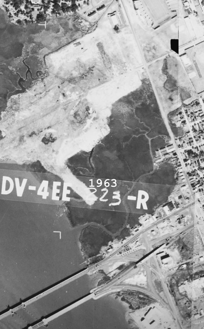
1963_AERIAL.pdf
Aerial photograph showing Gadsden Creek as well as the new Crosstown, Septima P. Clark Parkway - which demolished many African-American homes and effectively segregated the City of Charleston along racial lines.
1964_LDL.pdf
Evidence from Lowcountry Digital Library of the Black-owned buildings set to be demolished to make way for Septima Clark Parkway.
1965_PLAT.pdf
Proposed road (Lockwood extension) right through Gadsden Creek - evidence of City intention to make the area more accessible, desirable, profitable.
1969-07-PLAT.pdf
July 1969 Plat by Acting City Engineer of Charleston, demonstrating landfill area at Gadsden Creek.
1971-02-06_NEWS.pdf
News clipping from Feb 6, 1971 documenting Gadsden Green resident Shirley Chavis filing a suit against the City to prohibit trash dumping, citing horrific conditions: rodents, noxious odors.
+
1972 Plat showing “Proposed Location of City Police Station and Horizon House” - to be built on top of the landfill. Horizon House later demolished because it was sinking.
1971-02-08_USACE.pdf
After-the-fact permit issued by Army Corps. of Engineers to City of Charleston, after threatening legal action against Charleston’s illegal dumping into Gadsden Creek. On P. 6, they refer to Gadsden Creek as a “Ditch” - cited by WestEdge, despite numerous evidence supporting the fact that Gadsden Creek is a navigable waterway and essential fish habitat.
1972_CITY MEMO.jpg
Selections from a March 1972 memo regarding the City of Charleston’s failure to comply with conditions of the 1971 permit granted by the Army Corps. of Engineers. The City continued to dump trash in the closed landfill and when threatened with legal action, the City’s recommendation was to dump this refuse by the “swimming pool” area (see 1950PHOTO.PDF), ultimately seeking to dump trash at the feet of the Westside community.
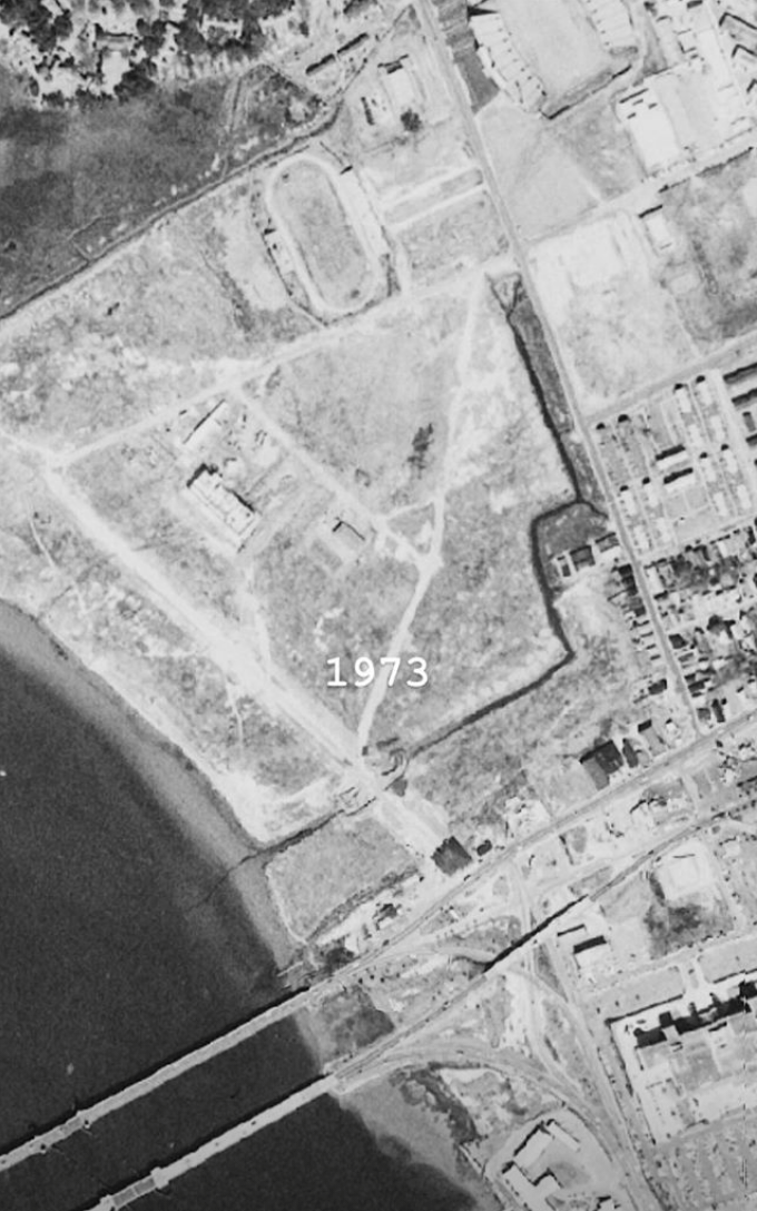
1973_AERIAL.pdf
Aerial photograph showing Gadsden Green public housing to the right, and the enormous fill area, with Gadsden Creek majorly channeled and forced into culverts. Depressing.
1973_DRAIN CALCS.pdf
Documents on Ashely Square Development’s proposed development that would have filled Gadsden Creek. The Army Corps. of Engineers calls bullshit on the developer’s claim that the development will provide better drainage by filling Gadsden Creek, with a handwritten annotating saying “NOT TRUE”, with handwritten calculations demonstrating flooding impact of filling the Creek, as well as 3 recommendations for alternatives, the first being “Place a bridge at the Gadsden Creek culvert site in lieu of the culvert.”
1973_PLAT.pdf
Another plat showing proposed Lockwood Boulevard extension right through Gadsden Creek.
1973_PLATS.pdf
1973 Plats showing Horizon House (a police station) one of the few structures allowed to be built according to the 1971 permit issues by Army Corps. Eventually demolished because sinking into the marsh. More plats explicitly showing Gadsden Creek as a waterway, not a ditch.
+
1969 letter from Mayor to employees on alternative measures for trash pick-up because of the Sanitation/Hospital Strike happening at the time.
+
1973 Report of Special Committee Appointed to Make Recommendations for Location and Plans of Brittlebank Park” - referring to Gadsden Creek by name as a nearby landmark and “Southern boundary of City property.”
1974-07-26_CITY.pdf
Mayor Gaillard acknowledgement of flooding due to landfill: “the result of settlement of the street as all of the area is filled land and the homes are on pilings… constant flooding which occurs with each spring tide.”
1981-08-25_USACE W/ NOTES.pdf
Army Corps. letter to First Piedmont Mortgage Company, who asked them whether Gadsden Creek area is a wetland. Army Corps. responds EXPLICITLY in the affirmative, that Gadsden Creek is a “channelized and relocated tidal creek” and NOT a drainage ditch.
2007_CHS Green PLAN.pdf
A Sustainability Plan developed over two years under Mayor Riley by the Charleston Green Committee advocating for working with natural features like wetlands, with a chapter on “Nature as Infrastructure of our Built Environment” - clear hypocrisy between the City’s declared ideals and its actual treatment of natural wetlands.
2012_LS3P.pdf
Master Plan of WestEdge development (then called “Horizon Project”) with identical footprint to the plan today, but INCLUDES the preservation of Gadsden Creek in its scope (bottom left.) Demonstrates at one point, the City was open to the idea of integrating Gadsden Creek into the development.
2013-02-25_HORIZON.pdf
Press release by Horizon Project Foundation (now WestEdge) on two finalists for the Master Development team for the project: Hughes Development Corporation, and Gateway (who was awarded the project.) Notably, Hughes is working on a creek daylighting project in Columbia, SC - the opposite of what is being proposed for Gadsden Creek. Missed opportunity.
2015_06-05NMFS.pdf
National Marine Fisheries Service letter to Army Corps. of Engineers in support of Gadsden Creek.
2015_PUBLIC COMMENTS.pdf
Table marking public comments made at hearing, for and against filling of Gadsden Creek.
2015-04-08_SITU.pdf
Student group design event to create alternative urban planning of WestEdge development.
2017-05_ARCHAEOLOGY.pdf
Document from The Charleston Museum, May 2017 - “Archaeological Explorations at 48 Laurens Street, Charleston, SC” with evidence that “The abattoir on the banks of Gadsden’s Creek, on the west side of the peninsula, was known as “Butcher Town.”
2018-05-30_USFWS.pdf
Letter from Fish and Wildlife Service (U.S Department of the Interior) to Army Corps. advocating for Gadsden Creek, saying that development would “merely exacerbate existing flooding”. Questions Open Space Institute’s mitigation of King’s Grant in Summerville as a fair trade “The Service questions if the proposed project to impact tidal, high salinity wetlands will be adequately mitigated using a site that is approximately ten miles upstream where the Ashley River consists of lower salinity, brackish waters.”
2018-06-18_SCDNR.pdf
South Carolina Department of Natural Resources to Army Corps. stating that “no basis or reasonable justification has been provided” for the filling of Gadsden Creek and that “we recommend the project as currently proposed not be permitted and the applicant pursue less damaging alternatives that further avoid and minimize tidal wetland impacts.”
2019_Survey of City Property to be Filled and Impacted via P_N 2015-00188 Applicant Comment Responses 04-24-19.pdf
From 2018 WestEdge Permit Application, survey demonstrating that City of Charleston is the majority landowner of the area to be impacted.